Contact Us

Use the form on the right to contact us.

Victoria Road
Auckland, Auckland, 0624
New Zealand

Devonport Heritage 2017, an incorporated society formed in 2017, promotes heritage and sustainable development in Devonport.

north head from mt vic.jpg

News

Ryman's retirement village - pushing for full public notification

Spokesperson McRae

Wakakura Crescent looking to Mt Victoria -Takarunga

Devonport Heritage is lobbying for public notification of the proposed facility at Wakakura Crescent/Ngataringa Road.  It seems a little disingenuous for this to be described as a "village" , when it is in fact a complex of multi-story buildings being inserted into a quiet residential neighbourhood.

We have no argument with a retirement complex as a concept, but the size and scale must be appropriate to the site and respect for the heritage aspects of the site should be front of mind.

At present the site is zoned Residential 4B, and whole the proposed Unitary Plan allows development of 3-4 storeys, this application is applying to build 5 and 6 storey blocks. The Urban Design Panel have looked at the application and in their opinion further consideration of heights and lengths of blocks is needed, along with looking at view-shafts between the blocks.

This issue has many aspects other than the widely publicised effects on traffic: i.e exemption for providing a public esplanade along the foreshore _"Pollys Park/ The Glade"; removal of trees; excavation and alteration of a heritage site ( all Discretionary Activities ) and the demolition of an Archaeological Site -Duder's Brickworks ( Non-Complying Activity)


Masonic Hotel

Claudia Page

Devonport Heritage is very concerned about the re-building process currently taking place at the Masonic site on King Edward Parade.

From media photographs it appears the whole of the hotel has been demolished, even the parts that were scheduled for preservation.

We have asked our local Auckland Council representatives to make inquiries into the level of demolition that has been taking place behind the white plastic shroud.  Council planners have replied that staff has been monitoring the works and have found them to be 'in general compliance'.

This is their official response:

" At Council¹s last scheduled inspection the works were in general accordance. Some parts of the building that were marked for retention/reconditioning were in worse condition (borer/rot and were crumbling, seen on site) than previously thought and had to be demolished. All extra demolition work has been reviewed and approved by Ian Bowman.  This approach is typical for projects of this type (where the exact condition of fabric is not known until works begin), and was provided for by the consent through the approved Conservation Plan and Conservation Methodology."

However we have very little faith in the process and believe this answer is a very convenient excuse for demolition. We have asked for proof in the form of photos about the state of the scheduled parts of the building. To prove that this is not a case of demolition by stealth we also ask that the council require a demolition plan which lays out exactly which original features that are Scheduled A items are to remain and which have been demolished and we would ask to be shown this as Environment Court submitters.  We believe this is the only way the community can have any faith in the process.  We are also concerned that the site owner has applied to change the resource consent for a cafe in the old hotel's ground floor into office space.  We have called for this application to be publicly notified as it is a marked change from the original consent and will effectively rule our any community engagement with the building and deactivate the corner. 

scheduled parts of the Masonic Tavern

Unitary plan hearings on heritage schedules

Claudia Page

This week we presented at yet another Unitary Plan hearing for Topic 79 - this was with regard to the Pre1944 Heritage overlay. Please find the text of our presentation on the link below.

We have one last hearing coming up, that one will deal with Precincts, including Wakakura Crescent where Ryman are planning their multi-storey complex and also covers Fort Cautley.

North Head and Torpedo Bay c.1930s (  Jackson family album )


information for submitters on 159 Victoria Road

Claudia Page

Making a submission on the proposed daycare in Victoria Road? Here are some of the details you will need and a link to a printable submission form. You can also fill in an on-line version on the council's website, and attach any supporting documents as well. SUBMISSIONS CLOSE AT 5 P.M THIS TUESDAY 9 FEBRUARY.

submission form

Submission form details to fill in:

The details to use in your submissions are:

Application number : LN2142117  Name of Applicant: Butterbee Childcare  Address of proposed activity: 159 Victoria Road, Devonport 0624

IMPORTANT - you must send a copy of your submission to the applicant as soon as reasonably practical c/- The Planning Room,  P O BOX 35 674 Browns Bay, 0753, attn. Duncan Ross.


have your say....

Claudia Page

159 Victoria Road, notified consent....

Devonport Heritage welcomes the opportunity to make a submission on the notified consent for a childcare centre at 159 Victoria Road, Devonport. 

The house at 159 Victoria Road is a significant heritage building that makes a strong contribution to a landmark corner of Devonport.

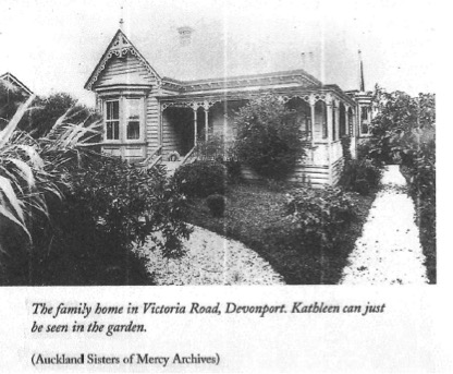
It was built in 1885/86 for Samuel Tanfield an important figure in early Devonport and the house, with its highly intricate fretwork, reflects his status.

Early photos show these original decorative details are still very much intact today giving the house a strong heritage impact on its surroundings.

Another important New Zealand figure lived in the house - Kathleen Niccol who became the renowned singing tutor Dame Sister Mary Leo. Dame Sister Mary Leo lived there from her birth in to about 1906, when they moved to the city. She was the great granddaughter of Henry Niccol who had the early shipbuilding yard at Devonport and granddaughter of the first mayor of Devonport, Malcolm Niccol.


The conversion of this heritage house to a large commercial child care facility will mean the permanent loss of the building as an historic home. The intrusive changes and additions will mean it will be no longer suitable as a residential dwelling.


The large addition to the rear and side of the house is of an unsympathetic design and will permanently detract from the standing of the house on its site. Aluminium joinery and a large access ramp abutting the historic house will be a further blight. The addition will mean the loss of one if the chimneys and the new building will be highly visible from the street and from Mt Victoria.


Overall the application demonstrates a lack of awareness of the heritage nature of the house. It does not include any analysis from a heritage architect on how the effects on heritage values could be mitigated by the proposed additions and alterations.

It claims the proposal is a good example of adaptive reuse but the house is quite able to continue as a residential dwelling or at the very least a small scale child care facility which would avoid the adverse effects of this present application.

Anyone can make a submission, it's an easy process. The application can be accessed from the Council website


 We wish to re-iterate that we are not opposed to childcare facilities, however we are concerned with the effect this will have on a historic home.  The application is non-complying.   Further historical background is available on our downloads page

The full text of our submission will be on our website prior to submissions closing on 9th February.

IMG_3119.jpg


news roundup

Claudia Page

Kathleen Niccol in the garden of 159 Victoria Road c 1900. She later became Dame Sister Mary Leo, singing teacher.

BREAKING NEWS >>>>>We’ve recently been supporting neighbours who are unhappy about the  proposed child care centre at 159 Victoria Rd which we believe should be a notified hearing. Today we have  been informed that this is being notified. A neighbour has done some fantastic research into the property revealing that among other things it was the childhood home of Dame Sister Mary Leo, who grew up there as Kathleen Niccol. The house dates from the late 1880s, and although it is not a scheduled property currently, there has recently been a nomination forwarded to Heritage New Zealand to register it as a Historic Place. We will put the research material on our Downloads page.

  Here's the link to the application and documents, and submission forms :

http://www.aucklandcouncil.govt.nz/EN/ratesbuildingproperty/consents/getinvolved/Pages/currentpubliclynotifiedconsents.aspx

Once again ,we have no issue with providing childcare, but this location has high heritage values being adjacent to a number of scheduled places and buildings – Dr Bennett's house next door at No. 157, the neighbouring group of local shops , St Leo’s school “hall”, the Jubilee Clock , the two historic churches, and the Mt Victoria graveyards.  Incremental changes will undoubtedly have a damaging effect on the overall character of the neighbourhood, and this is a particularly visible site, being on the main road into the historic village centre.  


In other recent news, Ryman Healthcare have unveiled development plans for a retirement village on their leased Ngataringa Road/Wakakura Crescent block . This will include 5 and 6 storey buildings on the 4.2 hectare site, which under the proposed Unitary Plan allowed staggered heights from 8 - 14.5 m (2- 4 storeys). The plan explains the logic for this as “ the large site areas of the precincts provide the opportunity to locate up to 4 storey buildings away from established residential areas, and surrounding areas generally to mitigate any adverse visual or dominance effect. 

In our submission on the plan we submitted that the Wakakura block should revert to the same zoning and density as the adjacent Ngataringa Road residential area.  In addition to this the housing immediately opposite has been retained in the Pre-1944 Historic Character Overlay. These groups of houses will be considered for inclusion in the Historic Character Zone that covers the main parts of Devonport. We will be speaking to the submission at hearings next year. Meanwhile multiple resource consent processes are underway. This includes determining if the public is able to have any input or not.

We have no issue with use of the land as a retirement village, but we are concerned with the visual effect of the buildings, dominance and how that relates to the heritage context of the street and underlying historic values.

This block of land has a very rich historical past, being the site of the early brickworks, and adjacent to the ancient maori portage from the Waitemata to Ngataringa Bay. Remains of the brickworks machinery can be seen as you walk through the bay-side glade, and it’s quite possible maori artefacts could be found too.

Purple shading and crosses show Pre-1944 Historic Character Overlay

Purple shading and crosses show Pre-1944 Historic Character Overlay


There are many concerns that are raised by this development and public debate and participation need to be allowed to occur.

Lastly, we are watching re-development of the historic Masonic Hotel with interest, subsequent to our earlier report of large-scale demolition.  It is to be hoped that as much historic fabric as possible is being restored for use in the building.

Our Annual General Meeting was well attended and the new committee will meet at the end of January. Meantime please contact us by e-mail devonport.heritage@gmail.com

Merry Christmas

Claudia Page - newsletter editor


Pre-1944 and Historic Character overlay changes

Claudia Page

As part of the Unitary Plan process, Auckland Council released updated maps on 30 October. These show the results of work on the precautionary Pre-1944 building overlay and also changes to the Historic Character overlay( previously called Special Character). Devonport Heritage are investigating the removal of the Historic Character overlay from the end of Stanley Point, which would give it different planning rules with regard to demolition, new buildings and additions and alterations to all other areas on the Devonport Peninsula. We had not been aware of any potential changes to the overlay, which has existed in Devonport for about 20 years. In the map below you can see the area with grey squares at the end of Stanley Point where it is now proposed that the overlay be removed. The blue shading shows areas to be retained. Pre-1944 areas have also been adjusted with a much smaller area now being considered. This particular overlay is likely to have a 'sunset clause' with heritage assessments completed within about 2 years of the plan becoming fully operative. 

Check back here soon for updates to this developing story.

PAUP - Revised maps of heritage overlays Devonport. Blue colour denotes Historic Character overlay to be retained. Mauve denotes Pre-1944 overlay to be retained.

PAUP - Revised maps of heritage overlays Devonport. Blue colour denotes Historic Character overlay to be retained. Mauve denotes Pre-1944 overlay to be retained.


Devonport Heritage Annual General Meeting 2015- Notice

Claudia Page

Notice of Annual General Meeting 2015

Our Annual General Meeting is held in late November each year. This year the meeting will be held on Monday 30 November. 7.30 p.m. at the Devonport Library. We welcome any member or supporter , or new member to come along hear what Devonport Heritage has achieved over the last year. To join our committee just come along and raise your hand when we call for nominations!

All regular committee meetings are also open to anyone who would like to come along participate or any resident who would like to raise an issue with us.

Please refer to the AGM page for last year's minutes and the

Apologies to devonport.heritage@gmail.com

The committee meets monthly usually on a Monday evening, from February to November.

$26 Million to be spent on Takapuna Grammar restoration

Claudia Page

The Ministry of Education have announced that they are to spend $26 million on Takapuna Grammar School's landmark Main Block. Main Block was earthquake strengthened in 1994, however this work was faulty and lead to the building becoming "leaky" and during recent scoping it has been found that the whole building will now need major restoration to avoid demolition. The cost is enormous, but we agree with local MP Maggie Barry -Minister of Arts Culture and Heritage, that it is "absolutely worth it"... " to lose it would be unthinkable" . The Main Block is a local landmark, scheduled as a Heritage Building in the Unitary Plan. The project includes building two new art rooms and is scheduled to be complete in 2017 which will be the school's 90th birthday.

The case of the disappearing suburb....the re-naming of Stanley Bay

Claudia Page

This is a guest post from one of our members on the strange case of the re-naming of Stanley Bay to Stanley Point. Jeremy has been advocating for the name change to be reversed and is asking for local support. See the 2002 Wise's map image below for the traditional suburb names and locations.

Wise's 2002 map image

When I moved back to Stanley Bay last year, I was surprised to find its name had been changed to Stanley Point. I believed it had been a simple error that somebody had made due to lack of local knowledge. My enquiries found that in 2007 the North Shore City council submitted a list of suburbs to be gazetted by the New Zealand Geographic Board. The name of the suburb of Stanley Bay was changed to Stanley Point. This was done despite the common and historical use of the name Stanley Bay for the suburb since at least the 1900’s, the collection of census data by Statistic New Zealand for Stanley Bay, and surprisingly against the recommendation of the Devonport Local Board that the name remain Stanley Bay.

A Brief History of the Area

Stanley Point was named after Captain Owen Stanley of the HMS Britomart who surveyed the Waitemata Harbour in 1841.

Historically, the locality referred to as Stanley Point consists of one main street, Stanley Point Road, running from the bay up to the point with two small streets, First Avenue and Second Avenue, running off it.

Stanley Bay was originally referred to as Brick Bay. A brick works was sited there from 1844 to the 1850s Calliope Road was constructed in the 1850s and after the establishment of the dry dock and the naval base the area was subdivided and settled. In 1899, the Harbour Board recognised the change of name from Brick Bay to Stanley Bay and in 1900 a ferry service to a new Stanley Bay Wharf started. By 1909 the population had grown and Stanley Bay School was established in Russell Street. In the 1920s, the Stanley Bay Improvement Association formed to reclaim part of Ngataringa Bay to form Stanley Bay Park, the recreation grounds house the Ngataringa Tennis Club (1927) and the former Girl Guides den.

The Stanley Bay area has eleven streets running off or parallel to Calliope Road, plus the Navy Base and accommodations, the Naval Hospital Buildings and the dry dock and Naval dockyards.

The Census defines Stanley Bay as the area west of Shoal Bay Road with a population of 2187 residents and, due to the dockyards, a working population of over 2000.

Documentation of the Name Change

The North Shore City Council report on the second (and final) consultation process records the following comments on the name change from Stanley Bay to Stanley Point (Advice of Action page 6, attached):

Devonport Community Board

Comments

·       Stanley Point suburb area marked on the second draft map is to be divided to Stanley Bay and Stanley Point suburbs.

Amendments

·       After further consultation with Councillor Dianne Hale and Andrew Eaglen, it was agreed that the area indicated for Stanley Bay was too small. Therefore Stanley Point suburb names remains as it is and Roslyn Terrace is the eastern boundary of the suburb.

·        

I believe that it was in these comments and this decision that a mistake was made, because the old Stanley Bay area was considerably larger than the Stanley Point area which, as mentioned, comprised only three streets. However, a North Shore City Council-erected map at the Devonport Wharf entrance (still extant) showing the localities of Devonport has the names Stanley Bay and Stanley Point around the wrong way. It shows Stanley Bay as sitting to the west of Stanley Point and suggests that it is Stanley Bay which has only three streets. The map is wrong, but it may explain the decision that was made

As the evidence suggests that the name change from Stanley Bay to Stanley Point may have been based on an error, I believe it warrants being revisited and reconsidered.

The N Z Geographic Board advises that the name can be changed back to Stanley Bay with support from the community and the Devonport Takapuna local board.


please e-mail your support to us and we will forward your details to Jeremy

Additional height controls for Devonport village centre

Claudia Page

Devonport Heritage made a submission to the Unitary Plan hearing panel today regarding Additional Height Controls which have been proposed for the Devonport main street. Margot MacRae represented us, read the submission below:

Submission by Devonport Heritage on Topic 078 30/10/15

1. Our organisation has called for Devonport’s commercial centre to be removed from

the Town Centre zone.

The principle reason for this is that the underlying height control of 12.5 metres is

inappropriate to the historic village centre of Devonport.

We have submitted that the business centre be scheduled as an historic place and we are

backed up by Heritage New Zealand.

2. Devonport is unlike the other areas zoned as Town Centres.

If you go across to Devonport this weekend you’ll find two Clydesdale horses pulling a

12- seater cart around the main streets. It’s a hugely popular visitor attraction.

It holds up the traffic but nobody toots or yells at it. It’s just part of the life there and has

been going for 23 years.

Can you imagine this in Parnell or Takapuna, Grey Lynn or any other Town Centres?

3. A height limit of 12.5 for the main Devonport centre will invite intensive

development which will put all that makes Devonport special, at risk.

The principle objective of the zoning is – that the scale and intensity of town centres is

increased .

This is entirely wrong for Devonport’s centre which is widely recognised as a highly

intact, authentic heritage area.

• The western side of the Victoria Road looks today largely as it did in the 1880’s.

• Heritage NZ is scheduling the Victoria Road as an Historic Area.

• There are 21 scheduled heritage buildings in the lower Victoria Road.

4. Yet the Town Centre zoning with its 12/5 metre height limit carries with it the seeds

of destruction of Devonport’s low key heritage ambience.

The heritage buildings could be increased by two storeys and the non heritage sites will

be built to four storeys and this will diminish and overwhelm the historic quality of the

village. It will be death by a thousand cuts until the heritage becomes a sort of window

dressing. At present it has an authenticity and much of this is because of the scale of the

buildings.

5. This height limit also clashes with the Height Sensitive Area for volcanic cones as

Victoria Road is entirely covered by the Mount Victoria HSA which is 8 metres.

It seems absurd to have two such contradictory zoning height controls.

6. Some Devonport commercial property owners support the 12.5 height.

The Devonport Business Association and one local property trust have submitted against

the HSA for Devonport as this will interfere with their proposals for increasing building

heights.

Their argument is that building to four storeys is the only way of growing the economic

viability of the centre. They say without this the village will die.

7. However when the Association’s submission to the panel was publicized in the local

paper the Flagstaff in July, it created a furore in Devonport. (see attached articles).

The local business owners were outraged they had not even been informed of the

submission made on their behalf and were very much opposed to it.

They argue that the main reason people come to visit Devonport is because it is a

beautiful seaside heritage village.

They recognise that increased height limits and adding storeys to heritage buildings

would put their businesses at risk by destroying the very attractions people come here to

see.

8. The outrage from the business community became so strong that the owner of the

Bookmark bookshop carried out a survey of the local businesses.

This showed that two thirds of businesses did not support the Business Association’s

submission to Paup.

Many were in fact outraged that the submission had been made without proper

consultation with them.

Even the Flagstaff in its editorial called for the DBA to withdraw its submission on

heights.

So this is a hot topic in Devonport and rightly so.

9. Not only business owners but residents too love and value the low-key heritage nature

of the commercial area. It is not like other places in Auckland and it should not be classed

as a Town Centre which comes with an open invitation to build 3 to 4 storey buildings.

This is not appropriate for Devonport.

10. I remember when the Super City was being set-up there was a lot of reassuring

statements made that the new city and the Unitary Plan would recognise and value the

unique areas of the city.

We are asking you to honour those promises and give Devonport the recognition it

deserves and remove its zoning as a town centre.

Auckland Heritage protection slashed in Unitary Plan proposal

Claudia Page

Herald Body cartoon October 2015

The New Zealand Herald has previewed proposed changes to heritage protection across Auckland. This is in response to the cautionary proposal stopping demolition of pre-1944 buildings until council had done survey work to identify whether any historic heritage had been ommitted from the heritage schedules. We are not able to view the maps as they are embargoed until 30 October, at which point we have a brief period to make further submissions.  However we are reasonably confident that through lobbying over 20 years much of our most treasured built heritage is either scheduled or subject to special zoning requirements that give some protections.

http://www.nzherald.co.nz/property/news/article.cfm?c_id=8&objectid=11531215

Masonic development.

Claudia Page

In August this year a number of members were in touch with us concerned over the level of demolition underway at the 1866 Masonic Tavern. We contacted Auckland Council with a list of questions regarding this and were assured all was in order with the consent. Recently the Flagstaff has published an article with photos showing the extent of demolition -http://issuu.com/devonportflagstaffnewspaper/docs/october2devonportflagstaff

http://issuu.com/devonportflagstaffnewspaper/docs/october2devonportflagstaff

We requested updates from Council, including a follow up thisweek via Cr. Chris Darby and have the following update this afternoon  "Council Compliance Officers met with the applicants Conservation Architect at the site on 2nd October.  They confirmed that the works being undertaken were in general accordance with the approved consent." Hmm "general accordance"??. Make of that what you will...


Griffiths photo - undated, private collection